Questions over slope management after Batang Kali landslide
Experts say Malaysia lacks the expertise needed to monitor and manage hillsides.
Just In
Malaysia lacks local authorities with the expertise needed to monitor and manage slopes, a geologist says in the wake of the tragic landslide near Genting Highlands about a week ago which has claimed the lives of 30 victims so far.
Nor Shahidah Mohd Nazer, a lecturer at Universiti Kebangsaan Malaysia, said there are very few experts capable of conducting comprehensive checks of hillsides and slopes
"Understanding slopes requires the combination of geological and engineering information, and some local authorities do not have the technical expertise to interpret the stability level of the slope in question," she told MalaysiaNow.
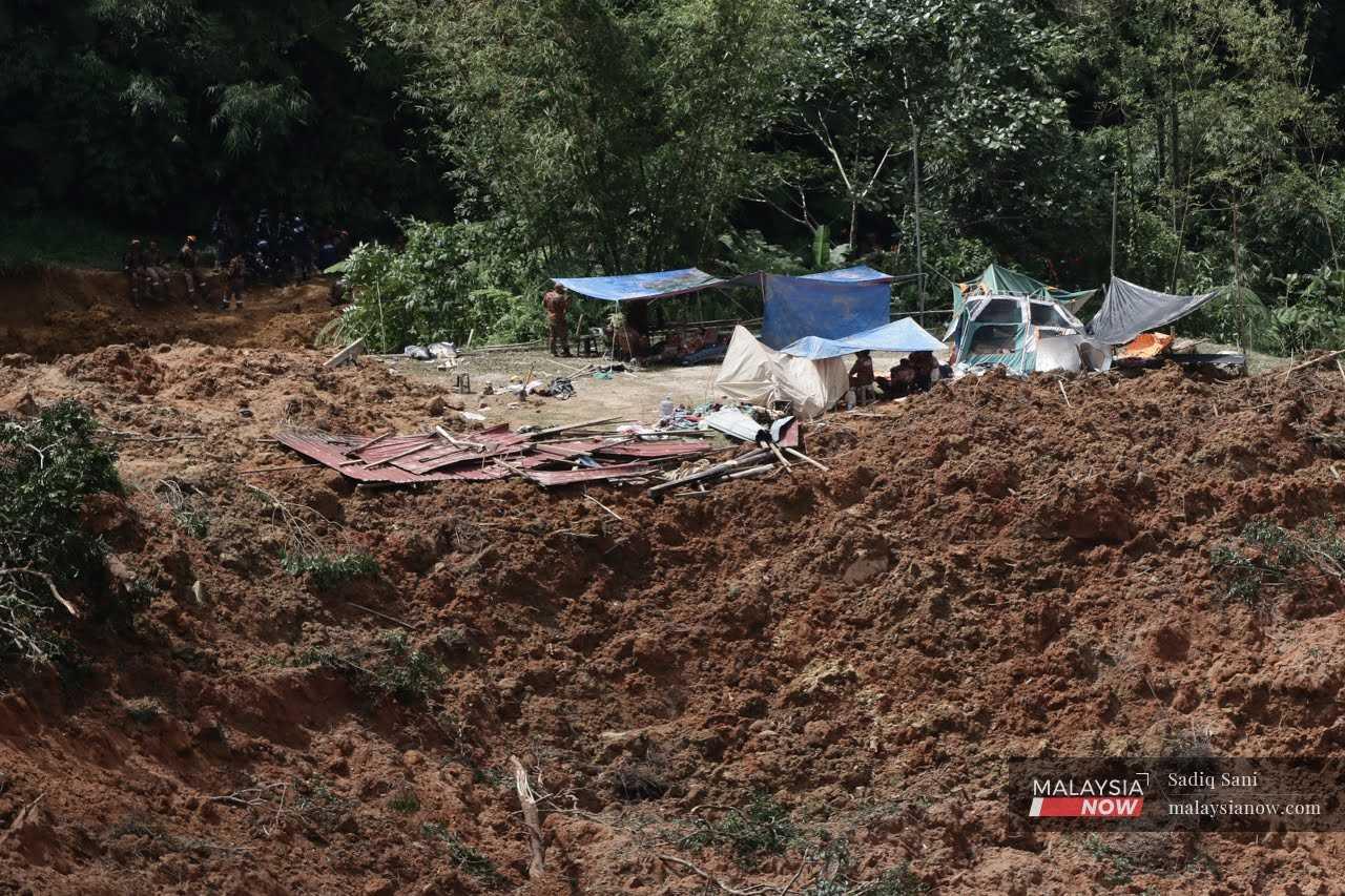
A total of 92 victims were involved in the Batang Kali landslide, which occurred at a campsite in Batang Kali.
In December last year, meanwhile, a landslide in Cameron Highlands claimed two lives.
Other major tragedies include the Highland Towers incident in 1993 and the Hulu Langat landslide in 2011.
Shahidah said the housing and local government ministry had issued a circular last year, stating several weaknesses on the part of local authorities or PBTs.
"Forty-nine percent lacked the governance structure and technical expertise to manage issues related to slopes or landslides.
"Seventy percent did not have a database for the collection of information, 81% did not carry out slope maintenance, and 41% were not aware of the existing guidelines related to slopes," she said.
And in terms of guidelines, she said, the circulation of more than one set had caused confusion, with the latest guidelines standardised only at the end of last year.
Mak Khuin Weng, formerly with the Petaling Jaya City Council (MBPJ), said local authorities only look at hillsides when an area is to be developed, or if there are activities such as agriculture to be carried out.
These situations would trigger the development plan clause under the Town and Country Planning Act, with experts sent to conduct a study.
"This geotechnical report will cover the possibility of landslides and prevention measures.
"This is normally done by private developers," Mak added.
In terms of the Batang Kali landslide, Mak said the road involved might have been owned by the government as the Public Works Department (JKR) had issued a statement in the wake of the incident.
"If it was JKR, they should have prepped a development plan along with the necessary reports on the possibility of land slope failure and prevention measures," he said.
"However, MBPJ had disputes with JKR over whether JKR needs to prepare these plans for the local government to approve when I was a councillor. This dispute was never resolved as MBPJ says JKR needs to apply while JKR says they don't need to.
"So, is Batang Kali under PBT? I don't know for sure. It depends on whether JKR submitted plans to PBT or not."
This however assumes that the landslide occurred from the top of a slope.
If it occurred from beneath, Mak said, the farm would have to obtain approval from the PBT and look at the probability of landslides.
Shahidah meanwhile said that a list of landslide hotspots could be obtained from JKR or the Department of Minerals and Geosciences, and landslide hazard maps from the Malaysian Space Agency.
Nevertheless, access to such data would require approval from the parties involved.
"Most researchers like us rely on landslide distribution maps, based on the history of recorded landslides," she said.
"These maps are publicly available in research journals."
Shahidah, who has studied the evolution of landslide geomorphology, said the presence of old dormant landslides meant that most slopes in the country are located in old landslides and could become active once more.
"We need to be prepared because the current climate variability greatly contributes to the reactivation of the slopes and exposes the country to the risk of extreme geo disasters."
Subscribe to our newsletter
To be updated with all the latest news and analyses daily.