Behind Shah Alam’s perennial floods
Experts explain some of the factors behind the flood problems in the capital of Malaysia's richest state.
Just In
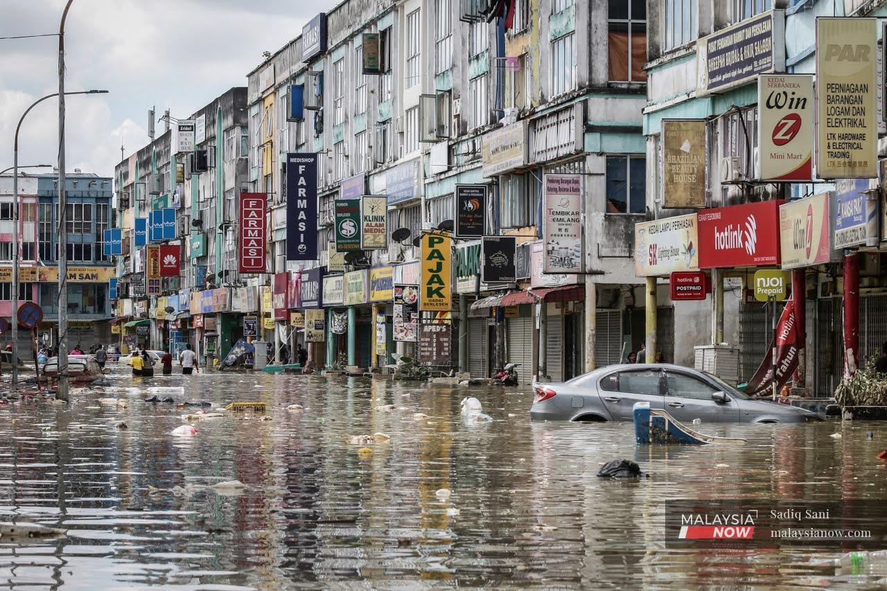
As the country continues to reel from the recent torrents which flooded areas in eight states and claimed the lives of 48 people so far, the question remains why Shah Alam, the capital of Malaysia’s richest state Selangor, appears perennially afflicted with this watery problem.
Experts who spoke to MalaysiaNow said much of the problem is related to the city’s topography.
Nik Abdullah Muaz Nik Mohd Kamel, a hydraulics engineer, said the Klang River – a major watercourse – flows through Shah Alam along with several smaller rivers such as Sungai Damansara, Sungai Kayu Ara, Sungai Rumpur and Sungai Payong.
“About 70% of flow rate of the Klang River basin joins at its confluence with Sungai Damansara,” Nik Abdullah said.
“This is where the flood-prone spots of Taman Sri Muda, Stadium Shah Alam and Taman Batu 3 are located.”
Heavy rainfall such as the deluge that came dumping down last weekend would cause the water levels to rise above the rivers’ capacities, he said, adding that these locations also lie in lowland areas.
Shah Alam was named the capital of Selangor in 1978, four years after the separation of Kuala Lumpur to become a federal territory.
Formerly known as Sungai Renggam, the following years saw Shah Alam transformed from oil palm plantations to a rapidly developing city.
Yet its topography and location downstream of the Klang River are against it during flood season.
The level of the river is also influenced by tidal conditions.
In the case of the recent floods, Nik Abdullah said, the physical landscape coupled with the month’s worth of rain that came pouring down in a single day on Dec 18 had resulted in large-scale floods throughout the area.
Just a few months earlier in September, flash floods brought on by heavy rain also caused damage to vehicles and houses in several areas including the vicinity of Stadium Shah Alam and Sections 4, 9 and 10.
Many have said that the floods should have been a warning to the authorities to take mitigation measures, especially in light of the increased frequency of such incidents.
Wardah Tahir, from the flood research group of UiTM’s engineer faculty, said rainfall aside, floods also occur in low-lying areas with a high percentage of impervious surfaces such as stadiums, parking lots, pavements made of cement or bitumen, and buildings.
She said such surfaces prevent run-off from infiltrating the soil or flowing into drainage systems at high speeds.
“Analyses show that the total area of the Sungai Damansara basin is 141 sq km. The developed area is 116.4 sq km and the forest area only measures 24.6 sq km,” she told MalaysiaNow.
“The higher the urbanisation rate, the more rain water turns into run-off.”
According to Nik Abdullah, Shah Alam’s structural and non-structural measures are based on the integrated river basin development and integrated flood management process.
Here, flood management efforts include the widening and deepening of rivers and the construction of tiers, flood walls, flood reservoir ponds, water pumps, water control gates and other means of disaster management.
However, he said this needs to be improved in line with the progress of development.
“Each structure is designed to accommodate certain flow rates,” he said.
“They are unable to accommodate floods that occur beyond the design rate.”
Wardah meanwhile said the drainage system was not working well, while the six existing flood reservoirs around the flooded areas could not accommodate the torrents.
Nikmatul Adha Nordin from Universiti Malaya’s town and regional planning department said the authorities should review the existing drainage system and its ability to accommodate run-off.
Speaking to MalaysiaNow, she said the opening of new housing areas must take this factor into account.
“Generally, new areas that are opened up are in higher locations. If floods occur, the new area is not affected but it increases the risk to surrounding areas,” she added.
Nikmatul said areas known as flood hotspots should be identified, and that new development should be prohibited in these locations.
“Open spaces need to be gazetted as green cover and bio-retention to filter and absorb surface run-off,” she said.
Subscribe to our newsletter
To be updated with all the latest news and analyses daily.
Most Read
No articles found.